Easements are the reason why. These recorded — and sometimes unrecorded — rights let a utility company run lines across a pasture, a neighbor use a shared driveway, or a pipeline operator cross a working lease. They hide inside legal descriptions, referenced exhibits, and decades-old deeds that never made it into the current owner's paperwork.
For oil, gas, and renewable energy projects, an easement nobody spotted can stall everything. The API notes that a pipeline company's permission to cross private land is documented in an easement, which defines the right-of-way and every obligation tied to it, and that construction only proceeds after authorization, permits, and that agreement are in place (API Guidelines for Right-of-Way Activities). Miss one during due diligence, and a drilling permit, pipeline route, or access road can get pushed back months.
This guide covers the documents you'll need, the methods that actually uncover easements, how to interpret what you find, and the mistakes that cause the most trouble.
Key Takeaways
- No single check catches every easement — combine deed review, county records, and utility checks
- Recorded easements appear in deeds and plats; unrecorded or prescriptive ones often don't
- Misreading legal descriptions and skipping the chain of title cause most missed easements
- Landman or title services cut risk on mineral rights and multi-parcel deals
What You Need to Identify Easements in a Title Search
How completely you uncover easements depends almost entirely on which records you can access and how far back you're willing to look. Skimping here means missing things later, usually at the worst possible time.
Documents and Records Required
Before starting, gather:
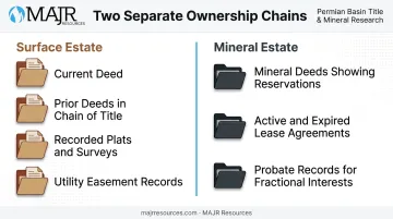
- Certified copy of the current deed: your starting point for any legal description
- Prior deeds in the chain of title: older grants and reservations often aren't repeated in newer documents
- Recorded plat maps and surveys: these show boundary lines and easement corridors visually
- Utility company easement records: many utility easements are granted directly and may not surface in a standard deed search
Access and Preconditions
You'll need a few things in place before you can search effectively:
- Access to the county clerk or recorder's office, either in person or through an online land records database
- For mineral or oil and gas properties, access to mineral deed and lease history, since ownership here is rarely as simple as surface-only property
- Basic ability to read legal descriptions so you can locate the correct parcel and any referenced exhibits
Mineral properties add a layer of complexity that surface-only searches don't have. Once mineral rights are severed from the surface estate, you're tracing two separate ownership chains, not one.
That means reviewing property deeds for reserved or excluded mineral rights, pulling active and expired lease agreements, and checking probate records for inherited fractional interests. A gap in either chain, surface or mineral, can leave an easement question unresolved.
Methods to Identify Easements in a Title Search
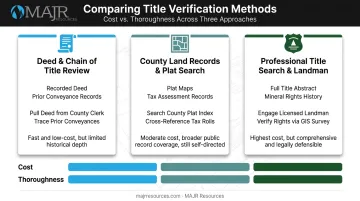
Which method makes sense depends on how thorough you need to be, what you're willing to spend, and how complicated the property's title history actually is. Most transactions benefit from using more than one.
Method 1: Deed and Chain of Title Review
This is the starting point for nearly every title search: examining the current and historical deeds for easements that were granted, reserved, or referenced in the legal description.
Documents needed: Current deed and prior deeds, obtained from the county recorder.
Steps:
- Request certified copies of the current deed from the county recorder
- Trace the chain of title backward through prior deeds, noting any referenced easement documents or exhibits along the way
Pros and cons: Low-cost and straightforward as a starting point. The catch — it can miss easements that weren't properly cross-referenced in the deed language, which happens more often than you'd expect with older records.
Method 2: County Land Records and Plat Map Search
This method uses recorded plats, surveys, and GIS mapping data to visually confirm where easements actually sit on the ground, not just what the deed says.
Documents needed: Plat maps, recorded surveys, GIS parcel viewer access.
Steps:
- Access the county clerk, assessor, or mapping department's records, online or in person
- Cross-reference the parcel number with recorded plats and any easement overlays
- Compare survey lines and markers to spot right-of-way corridors that aren't obvious from the deed alone
Pros and cons: This reveals easements geographically and can catch details a deed review misses entirely. On the other hand, GIS records can be outdated or improperly filed. The current ALTA/NSPS survey standard requires plotting record easements from supplied title evidence. Fieldwork is what confirms visible evidence and access on the ground, meaning records and physical inspection need to work together, not separately (ALTA/NSPS Minimum Standard Detail Requirements).
Method 3: Professional Title Search and Landman Due Diligence
For anything beyond a simple surface parcel, this is the method that closes the gaps left by the first two.
Documents needed: Full title abstract, surface and mineral ownership reports, lease history for oil, gas, or renewable projects.
Steps:
- Commission a full title search covering the surface estate and, where applicable, the mineral estate
- Have a title examiner or landman verify easement terms, validity, and the current holder of record
- Cross-check any recorded assignments or partial releases affecting the parcel
- Receive a title opinion or due diligence report flagging any easements that could affect development plans
Pros and cons: Most thorough and reliable option, especially for multi-parcel or multi-regional acquisitions. It costs more than self-research, but the cost is usually small compared to what a stalled drilling permit or blocked access road runs.
For companies managing oil and gas exploration, renewable energy development, or infrastructure projects, MAJR Resources provides full-title landman services that trace both surface and mineral chains of title independently. The team verifies each fractional interest and confirms no gaps or undisclosed easements sit between the current owner and the original grant. That kind of upfront verification is what keeps a project moving instead of stalling once construction crews are already mobilized.
How to Interpret Easement Findings in a Title Search
Finding an easement is only half the job. Misreading what it permits, or missing one that was never recorded, causes boundary disputes, blocked access, and stalled projects just as often as a missed search does.
Here's how to read what you find:
| Finding | What it means | Next step |
|---|---|---|
| Clear title / no conflicting easements | Legal description has no easement language, or only easements compatible with your intended use | Proceed with standard closing or development plans |
| Recorded easements with defined terms | Utility, access, or conservation easements with clear boundaries and named holders | Check whether terms restrict planned use, such as drilling pads or pipeline routes |
| Ambiguous or conflicting easements | Overlapping descriptions, missing referenced documents, or survey-deed discrepancies | Order a new survey or consult a title attorney before proceeding |
| Unrecorded or prescriptive easements | Worn paths, existing utility lines, or shared driveways suggest use without recorded rights | Investigate through neighbor or utility inquiry; consider a quiet title action |
That last category deserves extra attention. Prescriptive easements aren't based on recorded written instruments at all; they're established through open, continuous use over time. That means a standard records search will never catch them (Florida Bar Journal on prescriptive easements).
If you see a worn path crossing a property line or a utility line with no matching recorded grant, treat that as your cue to dig further. Don't assume the records told you everything.
Common Errors and Best Practices When Identifying Easements
Most missed easements trace back to the same handful of mistakes.
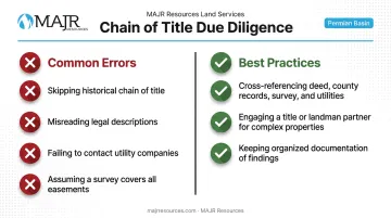
Common Errors
- Relying only on the current deed and skipping the historical chain of title, missing older granted easements
- Misinterpreting legal descriptions or metes-and-bounds language describing easement boundaries
- Failing to contact utility companies directly, missing unrecorded or informally granted access rights
- Assuming a survey alone reveals every legal easement, when some rights exist only in written record
Best Practices
- Cross-reference multiple sources, including the deed, county records, survey, and utility companies, instead of relying on just one
- Bring in an experienced title or landman partner for complex or multi-regional properties before finalizing transactions or development plans
- Keep organized documentation of every located easement and its terms, ready for later project phases
MAJR Resources handles this cross-referencing directly, combining historical title research with GIS-based verification so complex easements don't slip through during due diligence
Conclusion
Identifying easements in a title search protects against costly surprises and confirms your actual land use rights. It also lowers the odds of a dispute showing up mid-project. None of that happens through a single quick check.
Reliable identification means combining deed review, county records, plat searches, and professional verification, particularly for mineral estates or multi-parcel acquisitions where the chain of title gets complicated fast. MAJR Resources brings this level of diligence to energy, infrastructure, and property clients across Texas and the broader U.S. With that expertise in place, stakeholders can move forward knowing exactly what rights come with the land, and what doesn't.
Frequently Asked Questions
Who pays for a deed of easement?
The party benefiting from the easement, usually the grantee, typically covers drafting, negotiation, and recording costs. Grantor and grantee can still negotiate terms on a case-by-case basis.
How do I find easements on a property?
Review the property deed, check county land records and plat maps, contact utility companies directly, or hire a title company to run a full title search. Combining these methods gives the most complete picture.
What are the easement laws in Texas?
Texas recognizes both recorded easements and prescriptive easements, the latter requiring 10 years of continuous, open, and adverse use. Consult a local real estate attorney or title company for guidance specific to your property.
What is the difference between an easement and a right-of-way?
A right-of-way is a specific type of easement that allows passage across land. Easements broadly cover a wider range of permitted uses, including utility access, drainage, or conservation restrictions.
Do all easements appear in a title search?
Recorded easements typically appear in a standard title search. Prescriptive or unrecorded easements may not, requiring additional investigation such as a physical inspection or neighbor inquiry.
Can an easement be removed from a property title?
Yes, through abandonment, merger of estates, expiration of purpose, or a formal legal release. The exact process and requirements vary by easement type and state law.